CNES projects library
C
I
M
P
S
U
Jason 1 & 2
The Jason family comprises 3 satellites already in orbit, Jason-1, Jason-2 and Jason-3, launched in 2001, 2008 and 2016. These satellites’ mission is to acquire data on ocean level, wave heights and wind speed in real time. These data are processed by the SALP altimetry and precise positioning department at CNES, then used to monitor the oceans in real time, generate marine meteorology bulletins and compile navigation charts for shipping. They also help climatologists to learn more about climate mechanisms, in which the oceans are known to play a major role.
CNES, which has oversight responsibility for the mission satellites and system, is closely involved in developing the Jason satellites. The agency supplied the spacecraft bus, built by Thales Alenia Space. CNES also developed the two instruments on the Jason satellites, the Poseidon altimeter and the DORIS receiver. CNES and NASA, the initiators of the Jason mission, have since been joined by two new partners, Eumetsat (European Organisation for the Exploitation of Meteorological Satellites) and NOAA (National Oceanic and Atmospheric Administration). The Jason science data user community collaborates through the Ocean Surface Topography Science Team (OSTST), an international grouping of 80 science teams in France and around the world.
Mission's news feed
-

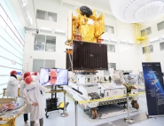
[Press] Space cooperation for climate science - SWOT satellite all set to depart for United States
After more than a year in assembly, integration and testing at Thales Alenia Space’s facility in Cannes, France, for the French and U.S. space agencies CNES and NASA, the SWOT...
September 7, 2022
-
[PRESS] Jason-2 altimetry satellite decommissioned after more than 11 years of ocean monitoring
The ocean-observing altimetry satellite mission, Jason-2, ended on 1st October 2019 following a joint termination decision made by the four mission partners (NASA, CNES, NOAA, and...
October 4, 2019
-
CNES’s OSTM/Jason-2 oceanography satellite mission marks its 10th year in orbit
On 20 June, the OSTM/Jason-2 mission (Ocean Surface Topography Mission) will mark its 10th year in orbit. Initially intended for a three-to-five-year mission, the satellite is...
June 21, 2018